10. The Giant’s Sconce

9. Garvagh Pyramid
6th March 2023
11. Glentaisie
7th March 202310. The Giant’s Sconce
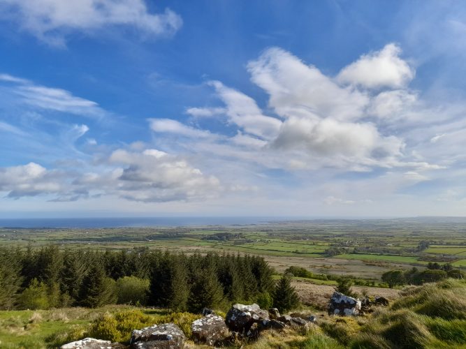
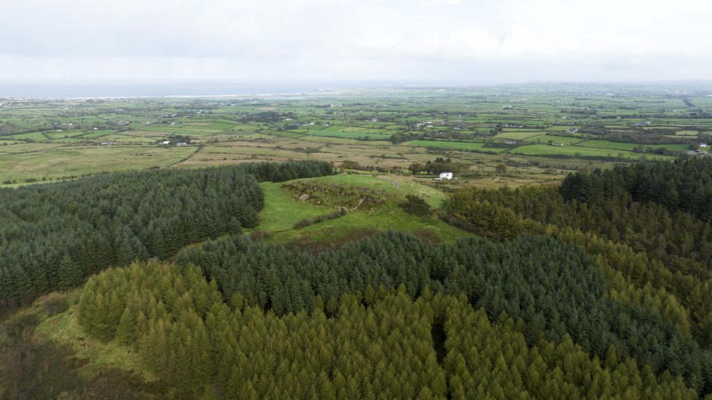
The Giant’s Sconce, on Sconce Hill, with extensive views in all directions was the ideal location for a hilltop fort.
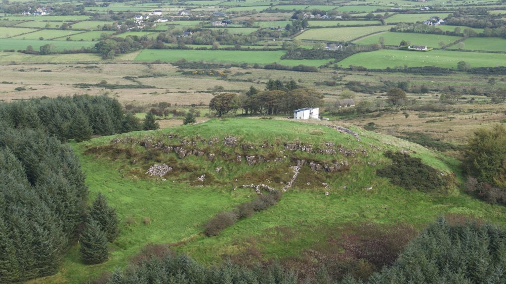
The oval Iron Age hilltop fort, 50m by 30m, with walls between 5m and 8m thick, is thought to be the ancient fortress of Dun Ceithirn – Ceithern’s Fort.
Ceithern was a descendant of Niall of the Nine Hostages, the legendary High King of Ireland. The Ulster Cycle, a medieval collection of Irish legends, refers to the fort as a royal site.
The Giant’s Sconce
By Hester McCunn
Ireland has a hugely rich ancient history which was passed down orally by its professional storytellers. Some of it is fictional, some not. Its mythical heroes were looked on as ancient gods.
One of these tells of ‘The road of the gods’.
This road/track-way runs in a straight line from Tara to Navan to the Giant’s Sconce. It crosses mountainous landscapes, chasms and bogs. The track was laid out by Laeg Riangobair (the son of the sea god, Manannan Mac Lir). Laeg had the skill to be able to keep a track-way in a straight line. He was Cu Chulainn’s charioteer. (Cu Chulainn ruled over the southern part of the province of Ulster and is famous for The Cattle raid of Cooley). This track-way was constructed by the people of the Other world (the fairy folk). The Giant’s Sconce was its most northerly point.
The Giant’s Sconce overlooking Castlerock and Portstewart.
The Giant’s Sconce was originally called Dun Ceithern. Ceithern was the grandson of Niall of the Nine hostages and a good friend of Cu Chulainn. (Some say the Sconce was also known as Dun da Bean at a time)
The Giant’s Sconce was an enormous stone cashew built at the top of Sconce Hill. The area would have been very bleak, inhospitable, with little shelter, only a few inhabitants but with a great vantage point at the north of Ireland. It was oval in shape (50m by 30m), with walls 5m thick and had a well in its centre. At the NE end there was a passage way 12m long and 0.6m wide. This made it larger and more easily defended than the Grianán of Aileach in Donegal. The Giant’s Sconce was destroyed by treasure hunters in 1827. Only some stones at the NE end remain. Gradually the rest were carried off to build field boundaries and farm buildings.
The Ordnance Survey Memoirs said: “The Giants’ Sconce which has a striking resemblance to the Grianan of Aileach is the most remarkable object of antiquity in the parish of Dunboe (insert footnote: the word giant is a modern addition to sconce) the name of the townland in which it is situated was formerly Lena Garran (horse meadow), now takes the name of Sconce].
Alfred Moore Munn described the walls of the fort as “of massive cyclopean masonry, nearly similar to that of the Grianan of Aileach,… and were clearly the work of some ancient pagan race, who inhabited Ireland prior to the Christian period…. The superstition was that the massive stones, of which the walls had been constructed, were the work only of giants, and hence the name Giant’s Sconce.
The ancient name appears to have been lungenn which, it is suggested, was a corruption of the still more ancient name of this fort Dun-Ceitirnn (Munitio Ceithirni) – the fortress of Kehern, or Ceithrinn. This fort was also called Dunkeherne (Reverend Edmund Hogan, Onomasticon Goedelicum).
Dr O’Donovan has clearly identified Dun-Ceithirnn with the Giant’s Sconce, and this townland of Sconce. The name of Dun-Ceitirnn is derived from Ceitirnn, son of Fintan, one of the famous knights of the Red Branch, who flourished in Ulster at a very ancient period.”[1]
The Giant’s Sconce.
The Northern Whig of 15th May 1934 carried a report about an excursion of the Belfast Naturalists’ Field Club, who along with the Londonderry, and Route Clubs visited sites around Coleraine, including the Giant’s Sconce. Guides for the excursion were Sam Henry, S Glassey, and Joseph Skillen.
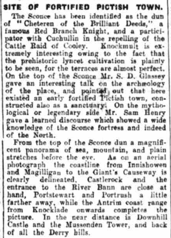
Northern Whig, 15th May 1934.
A letter from Sam Henry to the editor of the Northern Whig, about the Giant’s Sconce, appeared a few months later.
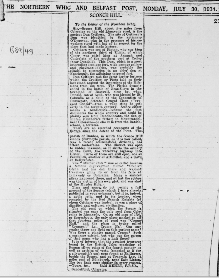
Copy of letter to the editor of the Northern Whig from Sam Henry, 30 July 1934.
Sir,- Scone Hill, about five miles from Coleraine on the old Limavady road, is the ancient Dun Ceithern. The site of Ceithern’s Dun was identified by the antiquary O’Donovan. Who in the presence of his co-workers stood with hat off in respect for the place that had made history.
Ceithern was son of Fintan, who was king of the northern third of Ulidia, of which Conor was the chief king at Armagh and Cuchulain of the southern part at Cooley (near Dundalk). This Dun, which is a most interesting iron-age fort, with passage gallery and cheveaux-de-frise, was probably the citadel in succession to an older dun at Knockmult, the adjoining terraced fort.
Dun Ceithern was the great border fortress which the Cruithni or Picts held as their last stand against the incursions of the Milesians from the west. The Pictish dynasty ended in the battle of Brae-Slieve in the townland of Bratwell, close by, when Donald, son of Aedh, who was blessed by St. Columba as a child at the Convention of Drumceatt, defeated Congal Clean (“wry-eyed Congal” – from a wasp sting he got) early in the seventh century. Sconce either means a candlestick – because the fort dominates the whole country and could be plainly seen from Dundabheann, the dun of Fintan (Ceithern’s father) in Mountsandel, near Coleraine – or else it is from the Danish, schans, a fortress.
There are no recorded occupants of the Sconce since the defeat of the Picts. The parish of Dunboe, in which the Sconce Hill stands (Formoyle parish, as it is now called, was a recent ecclesiastical division), has fifteen souterrains. The district was open to sudden invasion, as it skirts the estuary of the Bann, the waterway highway into Ulster. Three of these are still open, one at Fermullen, another at Artidillon, and a third at Ballywoolen.
The ”Murder Hole” was so called because a famous highwayman named “Cushie” Glenn had his den there and waylaid travellers going to or from the fairs at Limavady or Coleraine. Many a sinister affray happened there, and at last the robber was the victim of his own plot, and was shot at the Murder Hole.
Time and space do not permit at full account of the Sconce (which I have already published in your columns), but it is, indeed, a noble relic, and in its heyday, when occupied by the Red Branch Knights (of whom Ceithern was leader), it was a place of dignified and cultured civilization.
The old road on which the Sconce is situated was once the only road from Coleraine to Limavady. On an old map of 1720, or thereabouts, the only place marked on all that fourteen miles of road was “Crump Hall,” and the place is today called “Crumpa’,” i.e., Crump Ha’. Can any reader throw any light on this curious name? Was there a planter named Crump? Such a surname existed, but who was the person of that name who had a hall there?
It is of interest that the greatest treasures found in the British Isles consisting of Roman silver coins of the fourth century as well as articles of vertu (smashed as if or a silversmith’s use) were found at Ballinrees, beside the Sconce, and at Traprain Law, 15 miles east of Edinburgh, near East Linton. The two finds were similar in every respect.
Yours
Sam Henry, F.R.S.A., Sandelford, Coleraine.
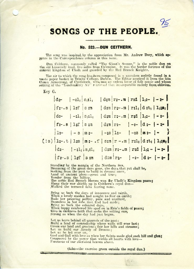
Dun Ceithern from the Songs of the People. Courtesy of the Sam Henry Collection.
[1] Notes on The Place Names of The Parishes and Townlands of the County of Londonderry, 1925, Alfred Moore Munn.
Directions
Co-ordinates: 55.1079, -6.7911
This project is receiving financial support via the District Council Good Relations Programme.