

400 years after the Plantation of Ulster, its legacy still divides us.
The Plantation1 made huge changes to our landscape, society and culture, but new discoveries are being made in the Causeway area that challenge our ideas.
What was the Plan?
County Londonderry2 was the cornerstone of the entire Plantation project and was set aside for The Honourable The Irish Society3. The Society's interest in the project was primarily commercial but it was also made responsible for ‘civilising’ the area, creating a loyal, lawful and trustworthy community.
The native population was to be replaced with English and Scottish Protestants. New, fortified towns and villages were to be built along with transport networks to support agricultural and industrial development.
Coleraine was the first ‘planted’ town in Ulster and, with Derry, was at the epicentre of this ambitious project.
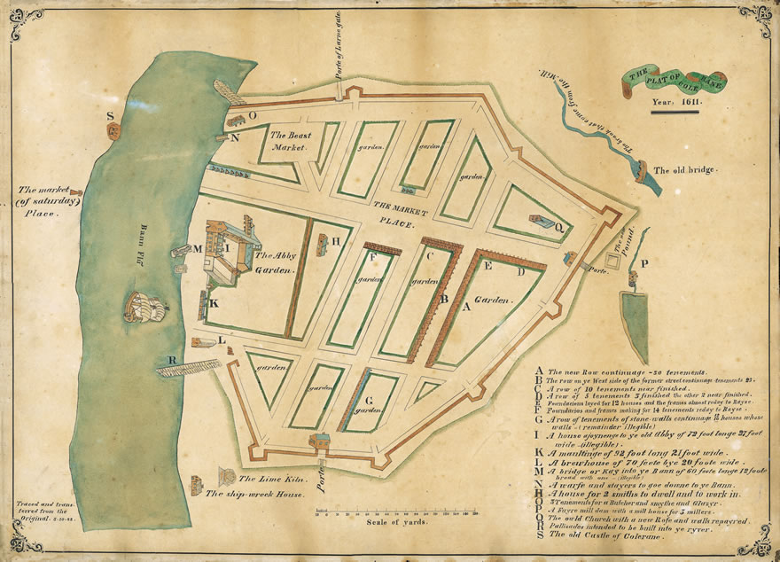
Carey's 1611 Plan of Coleraine Town – Crown copyright. Courtesy of PRONI
This formal street plan, featuring a large central market square and a Protestant church, and fortified by an earthen rampart and ditch, conforms to the ideal vision of a Plantation town.
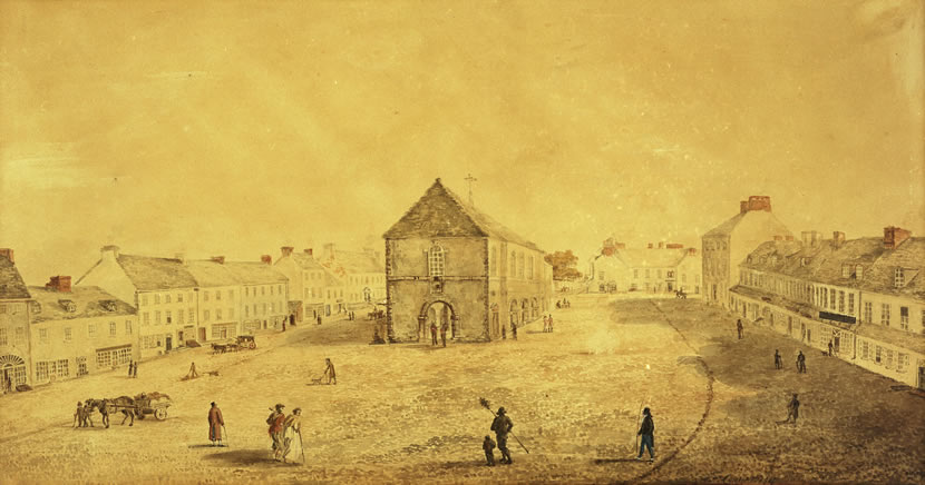
'The Old Market Building, Coleraine' by JH Campbell. Courtesy of Coleraine Museum
The Diamond is a common name for the market square at the centre of plantation towns. Markets were central to the Plantation project – it was assumed that control, regulation and commercialisation of the economy would also establish a ‘civilised’ society. Plans for Plantation towns usually also include a church and a jail.
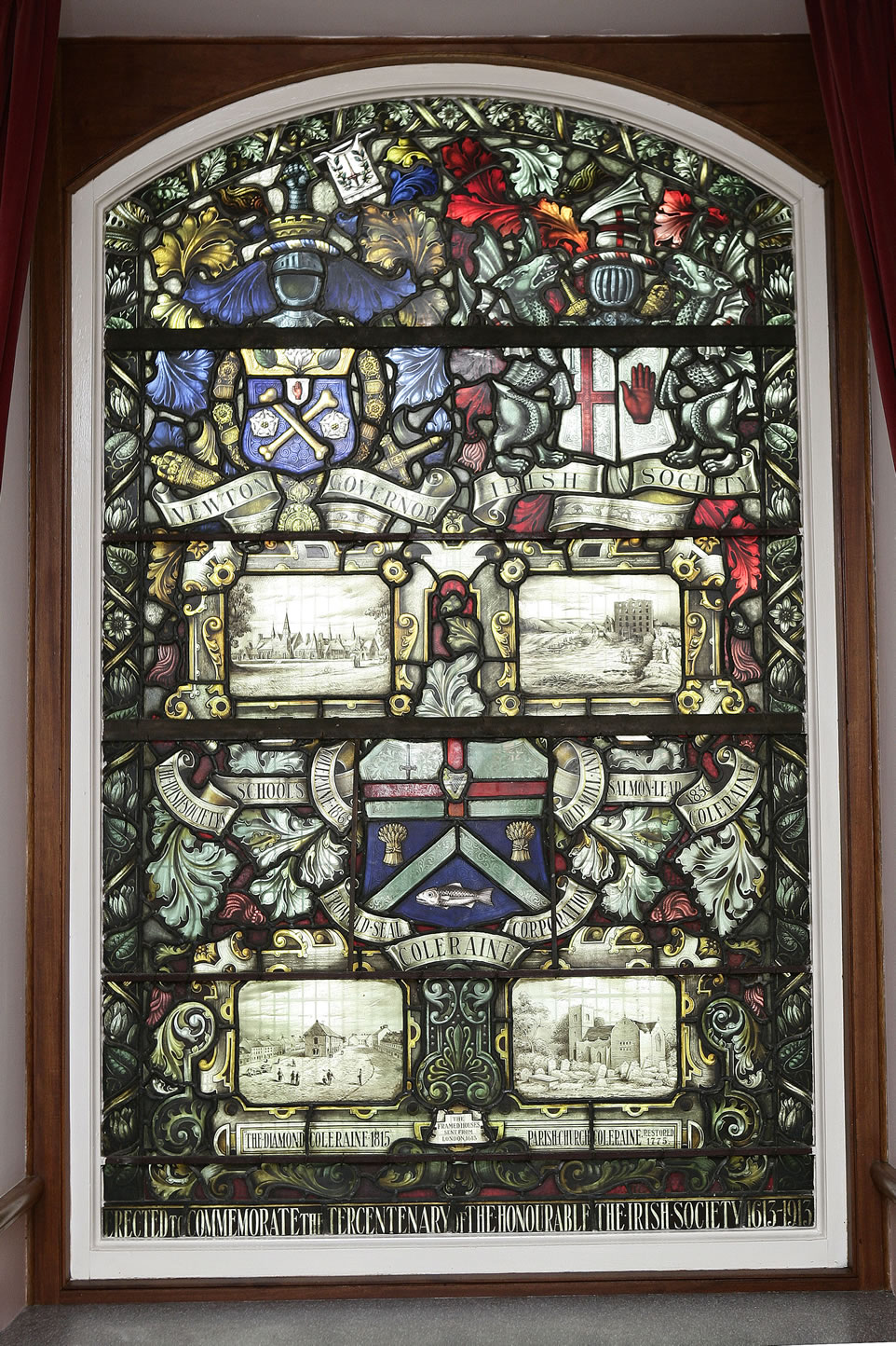
Stained glass window in Coleraine Town Hall. Courtesy of Coleraine Museum
The arms of Coleraine Corporation are surrounded by the Irish Society School, the Salmon Leap, the Market House in the Diamond, and St Patrick's Church – all legacies of the social and commercial investment by the Irish Society that continues to this day.
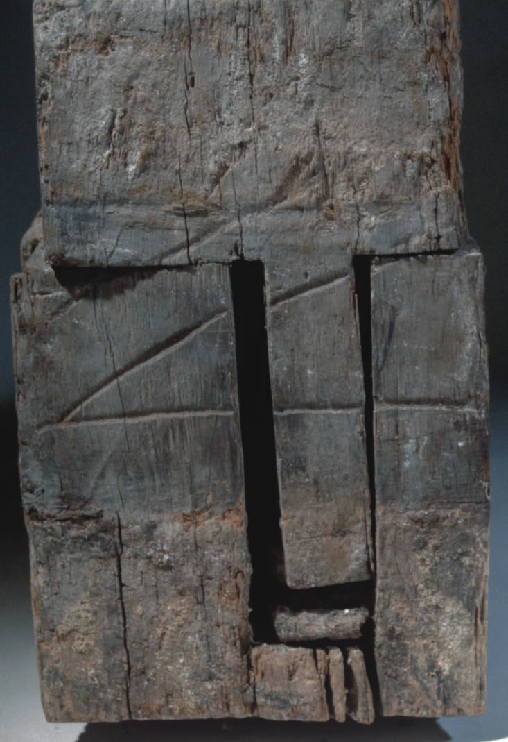
End section of the 1610 house timber found in Coleraine. Courtesy of NIEA
Uniquely, entire terraces of English-style houses were constructed using pre-fabricated wooden frames made from local wood shipped down the Bann. On this piece you can see the carpenter's mark used to match up the pre-fabricated pieces on site.
What was the reality?
Coleraine succeeded because it was built on an established ecclesiastical and trading centre, at a strategic crossing on the Bann close to rich local fisheries and forests. Other settlements on the frontier of the Plantation failed to conform to the plan and ultimately did not survive.
Movanagher bawn 4 was the headquarters of the rich and powerful Mercers Company. But the Mercers were unable to attract enough people to make the new settlement viable and were forced to rely on Irish tenants.
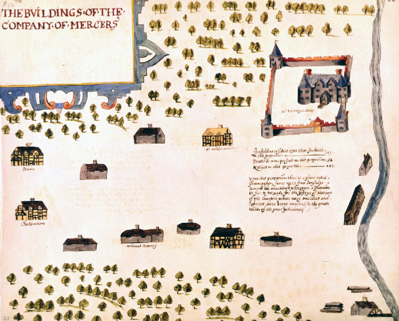
Raven's5 1622 Map of Movanagher – Crown copyright. Courtesy of PRONI
The map shows an incoherent settlement scattered through the forest, with four English-style timber frame houses, but six houses that are clearly Gaelic-style, probably built of woven branches covered in mud.
[Close to the bawn] are six houses of cagework, some covered with shingle, others thatched and inhabited by such poor men as they could find in the country, and these pay such dear rates for the land that they are forced to take Irish tenants.
~ Captain Nicholas Pynnar, 1619
In 1619, the population was recorded as 3 freeholders, 52 British men and 145 Irish men. The settlement was abandoned after the 1641 Rebellion8.
An Alternative Plantation
North Antrim was ruled by the MacDonnells, a Scots-Gaelic clan, and was not included in the English Plantation. But new archaeological evidence reveals that Randal MacDonnell undertook a plantation project just as ambitious as that west of the Bann.
Randal MacDonnell played a clever political game to ensure his own survival. He had sided with the rebel Irish during the Nine Years' War6, but by the Flight of the Earls7 he had switched allegiance and was able to hold on to his lands.
He attracted large numbers of Scottish merchants and tradesmen to the area – a strong cultural influence that endures today.
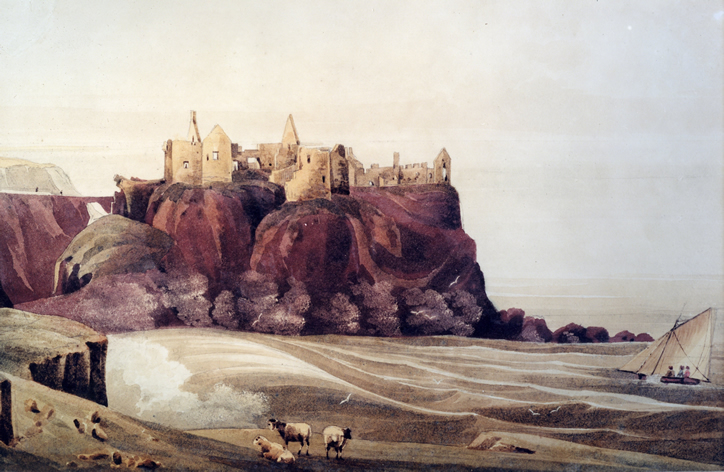
'Dunluce Castle' by Andrew Nicholl. Courtesy of Coleraine Museum
Dunluce Castle was the main seat of power for the MacDonnells. Here Randal MacDonnell built a substantial Scottish-style mercantile town that predates Coleraine.
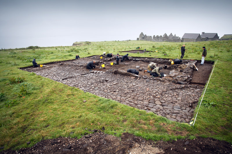
Excavation of merchant's house at Dunluce, 2009. Courtesy of the Centre for Maritime Archaeology, University of Ulster
In 2009 and 2010 the Plantation town at Dunluce was uncovered for the first time. The foundations were so perfectly preserved under the turf that even the plaster and paint on the walls survived in places.
It was amazing to uncover objects that people made and used 400 years ago
~ 1613-2013: The Legacy of Plantation Project Participant
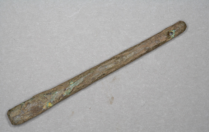
Early 17th-century bronze harp tuning peg. Courtesy of the Centre for Maritime Archaeology, University of Ulster
This rare object was found on the cobbled road surface at Dunluce. How it got there is a mystery… Was it dropped by an itinerant musician as he came from the town pub?
A Forgotten Story
The Plantation history of Dungiven has been all but wiped from popular memory in favour of the legacy of the O'Cahans.
The O'Cahans were the dominant Gaelic clan in the area. They established Dungiven Priory in the 12th century and added a tower house to it in the 16th century.
Only during archaeological excavations in the 1980s was it revealed that these buildings had been converted into a Plantation bawn and manor house in 1611. The remains of the Plantation buildings have been left exposed for visitors, but it is the story of the O’Cahans that remains foremost in the memory of the local community.
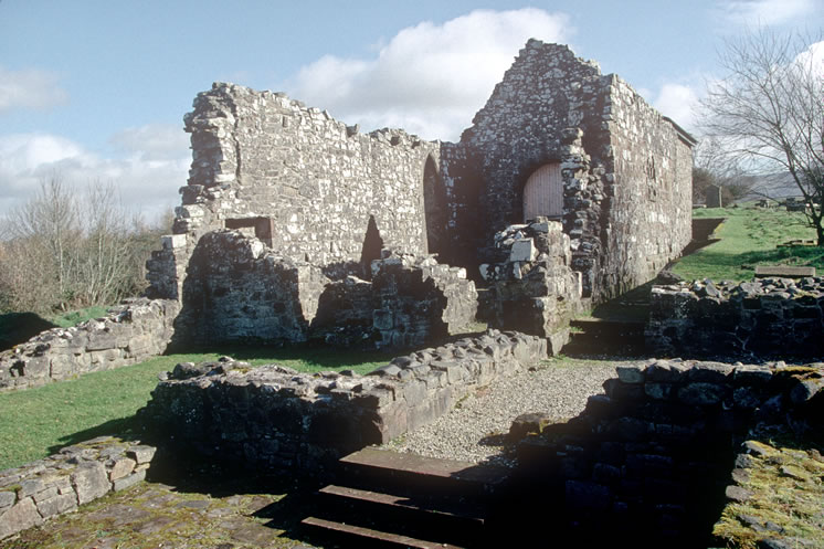
Dungiven Priory. Courtesy of NIEA
The foundations of the Plantation manor house can be seen to the fore. The graveyard to the rear reflects the diverse social, political and cultural history of the site up to the 19th century.
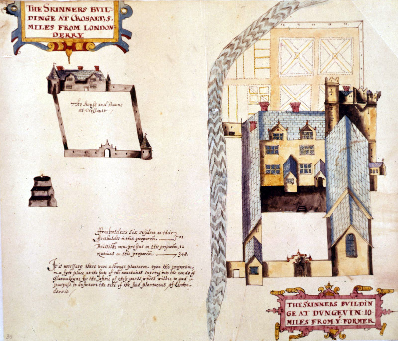
Raven's map of Skinner's buildings at Dungiven 1622 – Crown copyright. Courtesy of PRONI
The O’Cahan tower house and the Augustinian Priory have been incorporated into a bawn enclosing a grand manor house with formal gardens leading down to the river.
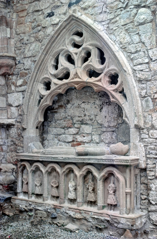
Carved tomb in the Priory Chancel. Courtesy of NIEA
This magnificent carved tomb is said to be that of Cooey-na-Gall O'Cahan, who died in 1385. However, its style shows it was made in the 15th century, probably by a stonemason trained in western Scotland. Remarkably, the tomb was preserved when the church was converted to Protestant worship.
What does it mean today?
Through exploring local sites and archival evidence a more complex relationship between Planter and Gael, British and Irish, Protestant and Catholic, is revealed.
And the story is not yet finished. Archaeologists and historians will continue to uncover new information and develop new interpretations.
So much has been blown out of the water. Stories and myths that we accepted as truth. Stories we grew up with.
~ 1613-2013: The Legacy of Plantation Project Participant
Find Out More
- 1↑The Plantation of Ulster bbc.co.uk/history
-
2↑County Londonderry
County Londonderry was created by the English Crown in order to persuade the London Livery Companies to invest in the Plantation project. To the old county of Coleraine was added the valuable ports of Coleraine and Derry and the rich forest of Loughinsholin, Co Tyrone, which would provide timber for building activities.
- 3↑The Honourable The Irish Society https://library.ulster.ac.uk/library/arts/ulsterscots/internetresources.php
-
4↑Bawns
Bawns were an essential part of the infrastructure of a Plantation town. They were formed of a perimeter wall, with squat towers at each corner, and a substantial manor house within the enclosure. Bawns were not intended for long-term defence or permanent garrison, like a castle. They were places of refuge in times of trouble. They were very effective against raiding but less secure against concerted assaults.
-
5↑Raven's maps
The maps of the London Companies' lands by Thomas Raven were commissioned in 1622 by Sir Thomas Phillips. They form part of the evidence submitted to King Charles I to support Phillips' charge against the London Companies that they were not fulfilling their legal obligations to implement the Plantation of Londonderry.
Find out more at bbc.co.uk/history/british/plantation/companies/lc02.shtml
-
6↑Nine Years' War
Spanning 1594-1603, the Nine Years' War was fought between the Gaelic Irish chieftains and the English forces in Ireland. Battles were staged all over the country but most of the fighting was concentrated in Ulster. The war ended in defeat for the Irish chieftains and their subsequent departure, known as the Flight of the Earls, paved the way for the Plantation of Ulster.
-
7↑Flight of the Earls
Following their defeat in the Nine Years' War, the Irish lords found their positions greatly weakened. In 1607 Rory O'Donnell, Hugh Maguire and Hugh O'Neill along with up to 90 of their family and followers, set sail for Spain with the intention of enlisting the help of (Catholic) King Phillip III. The Earls' plan was in vain, however - their boat was blown off course and landed instead in France. They were greeted cautiously by the authorities, who were wary of incurring the wrath of the English crown. The Earls travelled towards Rome, losing members of their party to illness and opportunity along the way. None of the Earls ever returned to Ireland.
- 8↑ 1641 Rebellion https://www.visitballymoney.com/1641-rebellion.aspx